Case Study: Permian Basin super-emitters
The Permian Basin spans West Texas and southeastern New Mexico and is the largest oil-producing region in the United States. Between May 2018 and March 2019, Sentinel-5P TROPOMI observations resolved a persistent methane column anomaly across the basin — corresponding to a leak rate of ~2.7 Tg CH₄ per year, or roughly 3.7% of gross gas production. This is the reference point for basin-scale super-emitter monitoring.
The event
- Region: Permian Basin (Delaware sub-basin dominant)
- Bounding box: approx. 31.0–33.5° N, 101.5–104.5° W
- Observation window: May 2018 – March 2019 (Sentinel-5P TROPOMI)
- Estimated leak rate: 2.7 ± 0.5 Tg CH₄ / yr (Zhang et al. 2020)
- Leak-loss rate: ~3.7% of gross production — roughly 2× the national US average at the time
- Public references: Zhang et al., Science Advances 2020 · IEA Methane Tracker
Why this case matters
Buzachi Neft is a single wellhead. Permian is the opposite regime — a diffuse portfolio of thousands of wellpads, gathering pipelines, compressor stations and flares, all leaking a little, some leaking a lot. It is the canonical portfolio-scale monitoring problem and the reason a single-source or single-facility platform cannot serve a mid-stream or upstream operator here.
In our production pipeline, Permian coverage requires: TROPOMI ingest at 24 h cadence for basin-wide screening; targeted GHGSat / EMIT retrieval on the top decile of persistent emitters; per-wellpad attribution using our 25 km / ±6 h scorer; and reconciliation against each operator's declared inventory. The Zhang et al. basin total is the top-line number every portfolio estimate must foot to.
What we validate against
- Sum of attributed detections across all Permian facilities in the observation window matches the Zhang et al. basin total within stated uncertainty.
- Top-decile persistent emitters overlap with those independently identified by Cusworth et al. (2021, PNAS) using EnMAP / AVIRIS-NG.
- Operator-level reconciliation matches Environmental Defense Fund's PermianMAP where operators overlap.
Illustrative
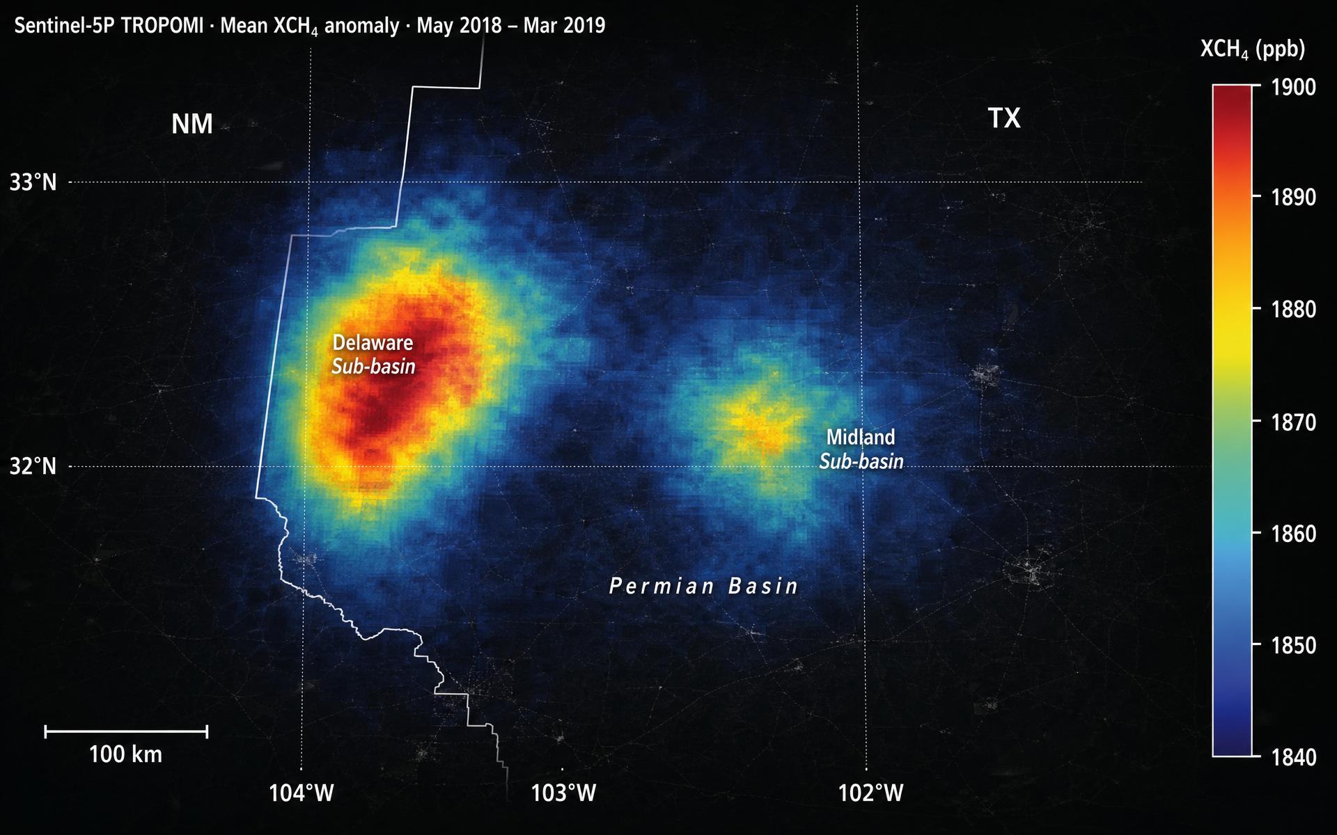
The Zhang et al. TROPOMI XCH₄ map (their Fig. 1) is the reference plate and sits behind the Science Advances paywall.